A friend of mine who is happily working on her own families cruising future asked about connectivity in Mexico. This was a huge question for me before we left so I thought I’d share our experiences.
Mobile Phone
Now, this might sound like an infomercial for T-Mobile. They have a great plan that provides us with unlimited talk, text and data and my phone works seamlessly between Mexico, Canada and the US. In fact, it worked just the same in France last year as well. It’s not cheap at $182/month for two lines with all the bells and whistles, but it is the main source of internet that we have and it costs the same and behaves the same whether I’m in Whitehorse or the Yucatan.
I use my phone as a hot-spot or tether to my computer. I’m not streaming Netflix but I am downloading and uploading documents, watching Youtube at times, emailing like crazy and looking up cool places to go in a town we just pulled into. As you can imagine, there are some places where I just don’t get great service. If we are near a town we will most likely have a good connection, but if we are a few miles out to sea, or up in no man’s land, the chances are slim of a good signal.
In places with poor reception we bought many a margarita at a beach side bar for their internet passcode. If you can find a restaurant that is in sight of your boat, then you can haul a repeater up the mast and amplify the signal, sit on your boat drinking your own margarita while poaching their internet. Ours was like this and cost just around about $40. There are much better repeaters out there today so definitely do your research.
Cell reception was remarkably successful though. I was able to connect a bit on the Pacific side of Baja in Turtle Bay and in Bahia Magdalena, the two major stops. Cabo San Lucas was also easy peasy. Once we started venturing up into the Sea or Cortez things got much spottier. You have to be near a larger city like La Paz to get a good signal. On the mainland side it was pretty much constant good connection from Barra de Navidad all the way up to Guaymas unless we were 20 miles off shore.
Since I’m still working I really needed to communicate regularly with the United States and Canada with a consistent phone number. If you don’t have this need I would highly recommend using a local provider such as Telcel in Mexico. You can easily stay connected for under $50 a month if you have an unlocked phone that can take a SIM card.
SSB Radio
When we are 20+ miles off shore and out of cell range we use our Single Sideband Radio (SSB) to connect. We have HAM licenses and have a program on our computer called SailMail. A ham license is not required but it gives you access to more email and voice options that go beyond the scope of this post. Basically, we connect to Sailmail via SSB (ICOM802 in our case) and a Pactor modem. Sailmail is a mail server running some serious compression software. This setup is not fast but it’s very cost effective and reliable (more reliable the further offshore). We did have our personal emails running through this but due to the limited bandwidth we used a tool in Sailmail called “shadow mail”. It receives all our emails but only shows us the first few lines. If it’s an email from REI we pass, if it’s an email from a client or family we click to accept it and it gets sent to our SailMail program on our computer. It’s a bit more complex than that, but… you get the idea. We can only download and upload text, no photos or attached files can be received or sent. We pay a small amount for SailMail, there is a free service called Winlink, but that one is required to be non-business and you do need a HAM license to access this. Don’t ask me… something to do with the FCC and that all HAM conversations on those frequencies are “of no significance…” ? It was actually on our HAM test….
If your planning a one year cruise or planning to limit yourself to coastal passage making it’s hard to justify the setup of an SSB ($5000+ if starting from scratch). If your plan is to move farther afield as ours is, it’s a nice addition both for email and for the social side of cruising.
Satellite Phone
Connecting via SSB can be tricky at times, especially close to shore and during the time of day when the sun is high. We used our satellite phone to create a connection to our Sailmail/Shadowmail when the SSB was temperamental, which was any time after 10am on most days. We didn’t really use the Satellite phone all that much but it was great to have for emergencies.
Navigation
This is us, anchoring on land… or at least that is what our chart plotter said.
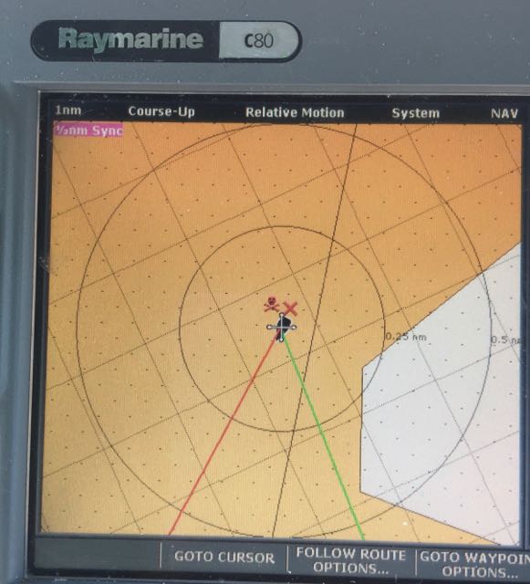
We suffered in Mexico with our aging chart plotter. Once we got out of San Diego the detail became laughably minimal and the background chart was about 2 miles off in places. We worked around it by entering waypoints, and because those and the boat were correctly positioned by GPS, we could avoid awash rocks, reefs and sunken vessels. But, relying on depth or detailed land shape information close to land was unfortunately not possible. Our eyes and depth sounder were the final confirmation and we never entered difficult anchorages after dark.
We sure kept our eyes up while close to land. We heard of more than one boat hitting awash rocks several miles off shore…and now you know why we like to be 20 miles out… We could have sent for the updated cards for our plotter via expensive and unreliable shipping, but we decided to just use our wits. Next time we go down we will be downloading one of the navigation apps. We watched lots of people use these with great success down there. You can get add ons with waypoints automatically in the program which coincide with the popular guides. Sailors sporting their iPads as navigation devices is a common sight and having it as a backup, or even a main source of navigation as long as you have another good backup is becoming common place where we were.
Thanks to T-Mobile, We also relied a bit on Google Maps with the satellite function more than once to see where the channel was in relation to our little blue dot on the map. Not ideal, but oh so handy when space is tight and cell service is abundant.
But don’t worry, if we get lost, we know what side the sun rises on and sets on, we know where the North star is and, although I have no idea how to use it, we have a sextant on board too…with instructions.
Bless you love for all this info!